Cartographic viewer of Spain
Imagen
Body
Mapping used:
Mapping used:
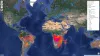
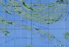
The active fire map is a service offered and produced by NASA FIRMS based on data collected by satellites. The information captured is processed quickly and made available to the public in a few hours. With all this, we can know in a fairly objective way the approximate place where a fire point has occurred and its magnitude.
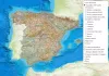
The Camino de Santiago is a historic pilgrimage route that starts from different places and reaches Santiago de Compostela, where the tomb of the Apostle is located. The map offers the complete route of all the Jacobean routes at European, Spanish and UNESCO-declared level.
The routes offered are the official ones made by the IGN from different collaborationsadores, with the information of the stages:
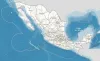
Cartographic viewer with Mexican spatial data infrastructure services, offered by the public body in charge of its publication. It allows you to explore different styles of topographic maps, aerial orthophotos and the hypsographic map of Mexico.
Mapping used:
Source and download of official data:
Mapping viewer with Brazilian spatial data infrastructure services, offered by the public bodies of its administration. It allows you to explore topographic maps and aerial orthophotos of some areas.
Mapping used:
Source and download of official data:
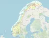
Mapping viewer with Norwegian spatial data infrastructure services, provided by the Norwegian Land Registry and Land Registry Authority. It allows you to explore and access information on topographic, historical maps, roads, aerial orthophotos, MDT, MDS or the administrative limits of Norway.
Mapping used:
Source and download of official data:
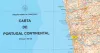
Official geoinformation pages of the Government Portuges:
Portal iGEO Geographic Information
Dire-o-Geral do Território (DGT)
Cartography used:
Cartography used:
Source and download of official data:
Mapping used:
Sources and download of official data: